Location: Northwestern Steuben County, Route 36, 3 miles south of Dansville.
This park features a very scenic gorge that is about 1 mile in length. Carved by the waters of Stony Brook, the twisting gorge has three major waterfalls. The Gorge Trail provides assess to two of the parks three major waterfalls. The third falls, known as the Upper Falls, is located well off established trails and can not be easily seen. Two stream fed swimming areas are located in the park. A campground has been established in the southern end of the park.
Before starting your hike, be sure to pick up a helpful brochure on the Gorge and West Rim Trails. It will inform you about the areas marked by the numbered or lettered wooden posts that you will encounter on the trails.

 Starting from the lower park parking lot, follow the path to the snack bar, and then head towards the southeast, to the lower swimming area. This is the trail head for the Gorge Trail, which is about .8 of a mile long and ascends roughly 230 feet. The setting of the swimming area is a delight, with Stony Brook emerging from the gorge and flowing into the enticing cliff side pool. As you continue southwards along the trail the scenery will only improve.
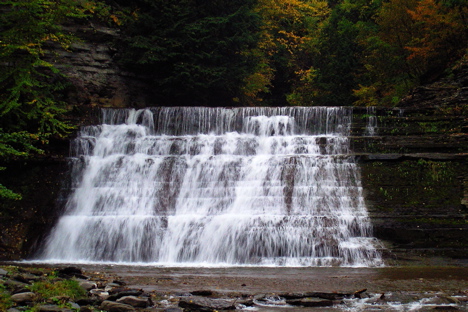
Roughly 0.4 of a mile past the swimming area, after passing several charming small waterfalls and rapids, you will cross the brook for the second time. An interesting falls can be seen from the bridge. Click here for a photo of Second Bridge Falls. Continue along the trail and shortly you will be able to see the Lower Falls in the distance. It is 36 feet high, has a 40 foot wide crest and faces to the northwest. During the summer months, lower water levels cause the brook to only descend the western flank of the falls, making it appear dramatically narrower. But no matter what the volume, this extremely steep and picturesque waterfall is always a pleasing experience.
 Continue along the trail as it ascends beside the Lower Falls. Just past the crest of the falls you will enter a small wooded area with many hemlock trees. A short distance beyond the woods is the Middle Falls. It is a multi-terraced waterfall that is 25 feet high. It faces to the northeast, and has a 50 foot wide crest.
Roughly 800 feet beyond the Middle Falls you will notice some concrete pillars in the brook bed. In the past they supported a railroad bridge that spanned the gorge. It was removed in the early 1940's.
Shortly the trail will begin its ascent to the top of the gorge and the upper parking area. Along the way you may be able to catch a glimpse of the Upper Falls between the trees to your left (east). Click here for a photo of the Upper Falls. This falls faces to the north northwest, is 42 feet high with a 42 foot wide crest. At the top of the gorge you will encounter the West Rim Trail to your right (west). You can follow this trail northwards for 3/4 of a mile and arrive at the lower parking area, where you started this hike.

 You can send me e-mail at: