Location: Central Tompkins County, Route 327, five miles south of Ithaca. From the intersection of Routes 13 and 327, located 2 miles south of Ithaca, follow Route 327 west for 0.3 of a mile to the Lower Park Entrance, or an additional 2.2 miles to the Upper Park Entrance.
A 4.6 mile hike is required to get from the upper end of Enfield Glen to the lower end and return. While the hike along Enfield Creek is very scenic, it requires quite a bit of time and effort. Since the highest and more interesting waterfalls are located at each end of the glen, I have chosen to describe only these areas.
 Beginning at the Upper Park Entrance, park in the lot closest to "The Old Mill." This area was once known as Enfield Falls, a small community that grew up around the mill in the early 1800’s. Located behind the mill is the Falls by The Old Mill, sometimes called Fish Kill Falls because it is located on Fish Kill, a tributary of Enfield Creek. This is a terraced waterfall, with two nearly equal leaps that total 15 feet in height. The 15 foot wide crest of the first leap faces to the northeast, with the crest of the second leap facing more towards the north. A small set of rapids, found just downstream of the falls adds to its charm.
After viewing the Falls by The Old Mill, walk downstream (eastwards) along Fish Kill. In roughly 400 feet turn right, (southwards) crossing over the kill, to a large wooden sign depicting the park trails. The parking lot and the area you have just passed through are located in a section of the very old interglacial gorge, ahead of you lies a remarkable section of the more recent post glacial gorge.
Follow the Gorge Trail and in roughly 600 feet you will enter Enfield Glen. Notice how vertical cracks in the rock, called joints by geologists, have controlled the course of the creek. In several places the gorge walls are so straight and flat that they appear to have been cut by a giant’s saw. Continue along the trail, passing by several interesting chutes, flumes, and small waterfalls.
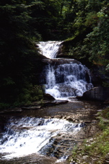
Soon you will cross over a small bridge and shortly enter an area of the glen known as the Devil’s Kitchen. Here you will encounter Devil’s Kitchen Falls. It has a height of 15 feet and a 35 foot wide crest that faces to the south southeast.
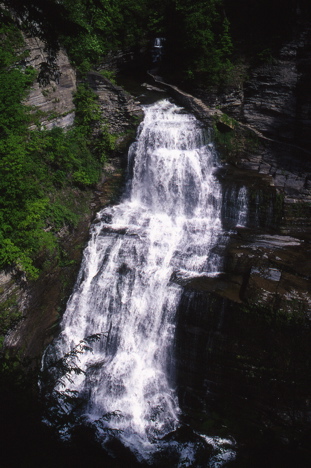 Just beyond Devil’s Kitchen Falls is the 28 foot wide crest of Lucifer Falls, which plunges 115 feet between towering gorge walls. The trail turns eastwards near the crest of the falls and quickly begins to descend deeper into the gorge. To your right are splendid views of the upper portion of the falls. Ahead of you the gorge quickly widens, allowing you to see downstream for a very long distance. This is another section of the interglacial gorge. Notice how it is heavily wooded compared to the post glacial gorge you just passed through.
Continue along the trail until you reach a bridge to your right (south). Cross the bridge, entering a wooded area, and soon you will come to the base of some stone steps ascending the side of the gorge. This is the Rim Trail, and it climbs the side of the gorge in a series of switch backs that will give you a good workout. Shortly after you reach the top of the gorge you will be rewarded with a stunning view of Lucifer Falls. From this view point you can see the face of this splendid falls. This view point is roughly 300 feet above the plunge pool of Lucifer Falls.
After you have viewed Lucifer Falls continue westwards along the Rim Trail, passing through a Red Pine forest. In roughly 0.3 of a mile you will arrive at the large wooden trail sign that you encountered near the start of the hike.
To view the Lower Falls, enter the park from the Lower Entrance and park at the western end of a parking lot located a short distance past the Park Office. From the parking lot, walk westwards along the access road about 600 feet to the park bathhouse. Just past the bathhouse is a large swimming area fed by the waters of Enfield Creek.
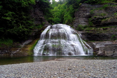 At the northwest corner of the swimming area is the Lower Falls. It faces to the south and falls directly into the swimming area. During the swimming season, a wooden dam is installed across the creek a short distance downstream of the falls. This dam creates the swimming area, with two diving boards, by flooding the basin below the falls. While the resulting pool of water drowns the lower portion of the falls, it also provides you with a very picturesque and unique swimming experience.
The Lower Falls has a natural height of 32 feet. Enfield Creek is about 20 feet wide as it flows from the shadowy glen above the falls. After passing over the convex crest of the falls, the sparkling waters fan out quickly and descend the steeply sloped face of the falls. At the base of the falls the creek is nearly 70 feet wide.

 You can send me e-mail at: