Zoar Valley Waterfalls
Gowanda, New York
Location: North central Cattaraugus County, Forty Road, 4.4 miles southeast of Gowanda. A parking area is at the end of Forty Road which is off of Point Peter Road.
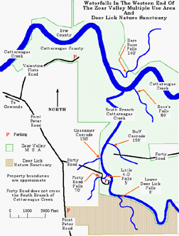
  Zoar Valley is a roughly 11 mile long canyon eroded by the the Main and South Branches of Cattaraugus Creek. Most of the valley is located in the Zoar Valley Multiple Use Area which is managed by the the New York State Department of Environmental Conservation. While the valley is an extremely scenic area it can also be extremely dangerous, with cliffs over 300 feet high and swift flowing water. Use caution when hiking in the area and do not enter private property without permission. While the Zoar Valley area has over 20 waterfalls I have chosen 7 of the more accessible ones located in the western end of the valley to describe. For my full size map of the area click here. Zoar Valley is a roughly 11 mile long canyon eroded by the the Main and South Branches of Cattaraugus Creek. Most of the valley is located in the Zoar Valley Multiple Use Area which is managed by the the New York State Department of Environmental Conservation. While the valley is an extremely scenic area it can also be extremely dangerous, with cliffs over 300 feet high and swift flowing water. Use caution when hiking in the area and do not enter private property without permission. While the Zoar Valley area has over 20 waterfalls I have chosen 7 of the more accessible ones located in the western end of the valley to describe. For my full size map of the area click here.
The following hike is strenuous, is roughly 3.8 miles long and recommended only for well experienced hikers. Take along food and something to drink. Give yourself plenty of time to get back to your vehicle well before dark.
As you drive down into the valley on Forty Road you will pass Forty Road Falls to your right. The small stream plunges 70 feet from a cliff right next to the road and then passes under the road. Continue down the road to a parking area at the end. Be sure to read all the information at the kiosk before starting your hike.
From the parking area head southwards and follow the path down to the South Branch of Cattaraugus Creek. You will have to climb down a small drop to reach the creek bed. Walk upstream along the western bank of the creek and in about 0.3 of a mile Lower Deer Lick Falls will be on your right. The falls is 6 feet high and has a 4 foot wide crest.
From Lower Deer Lick Falls head back towards the parking lot walking along the creek bank. A short distance past an old abutment for the Forty Road bridge over the South Branch watch for a small tributary stream to your left. This is the stream that Forty Road Falls is located on. Follow the stream into the woods a short distance to view Little 4-D Falls. This is a small ribbon cascade that is 5 feet high with a 12 foot wide crest.
 
Return to the South Branch and head downstream. About 0.2 of a mile from the old bridge abutment you will arrive at the base of Gossamer Cascade. For a better view of this 130 foot high cascade you will have to cross the creek. Choose your crossing spot carefully, avoiding swift moving water and being mindful of loose and slippery rocks.
 
After viewing Gossamer Cascade continue into the woods while keeping a eye out for poison ivy. You will come to a trail in a short distance. Turn left and follow it downstream. In roughly 0.2 of a mile there is a side trail leading to Buff Cascade. The cascade is located about 300 feet from the South Branch. It is a ribbon cascade being 120 feet high with a 6 foot wide crest.
 
From Buff Cascade return to the South Branch. You can either follow the trail or the stream for Buff cascade. When you reach the South Branch head downstream. In around 0.7 of a mile you will reach the confluence of the South Branch and the Cattaraugus. Continue around the bend following the Cattaraugus upstream. Roughly 400 feet from the confluence watch for a tributary stream on your right. Follow it for 150 or so and you will be at the base of 80 foot high Ross's Falls.
From Ross's Falls return to the Cattaraugus. If the Cattaraugus is low and you have experience crossing large creeks you may want to take a look at Bare Bunns Falls. Choose your crossing spot very carefully. Use extreme caution and cross with a friend using each other for support. Avoiding the swift moving water and be mindful of loose and slippery rocks underfoot. If in doubt about the route ahead turn back and choose another spot. Once you cross the creek you will have to bushwhack your way the base of Bare Buns Falls as there is no well defined trail. Located in Erie County Bare Bunns Falls is 140 feet high with a 6 foot wide crest.
To return to your vehicle follow the South Branch of the Cattaraugus upstream, retracing your steps.
For a MapQuest map of the area click here.
For a ACME Mapper 2.0 map of the area click here.
Web site: Zoar Valley Nature Society
Copyright © 2007 by Scott A. Ensminger.
This information may not be reproduced without written permission.
 You can send me e-mail at:falzguy@verizon.net
Return to Waterfalls You Can Visit In Cattaraugus County
Return to Waterfall Listing By County
Return to Home Page of WNYWS

|


 You can send me e-mail at: