
The Falls at Clarendon
Clarendon, New York
Location: East central Orleans County, Route 237, Clarendon. Parking is available in a community park, about 0.1 of a mile south of Route 31A.
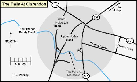
 The Falls at Clarendon is located about 200 feet to the west of the parking lot. You can walk directly to the base of the falls or follow a trail crosses the creek near the picnic pavilion. To the southeast of the picnic pavilion, near Route 237, is a New York State Historic Marker that mentions the early history of the area.
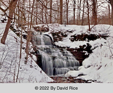
The falls has a total height of 26 feet, an 8-foot wide crest, and is 23 feet wide at the base. The East Branch of Sandy Creek cascades somewhat before making a vertical leap of 7 feet. After the first leap there is a short break, after which the creek fans out to a width of about 20 feet. The remainder of the drop is an extremely steep cascade that has some free-falling sections. The falls faces to the east and is illuminated nightly.
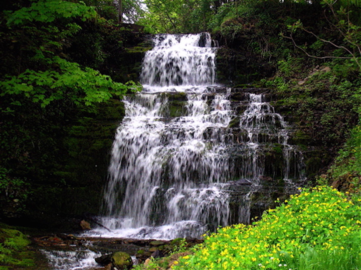
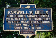 The Falls at Clarendon was discovered in 1810 by Eldridge Farwell, while looking for his brother's stray horse. Recognizing the potential water power of the falls, he returned early the next year, and built a saw mill and later a grist mill in 1813. Clarendon was originally known as Farwell's Mills, the name being changed when Orleans County was established in the 1820s. A spring-fed pool, a short distance upstream of the crest of the falls, was used as a baptismal site in pioneer days.
In the 1870s-80s Ogden Miller and Walter Pettengill owned a saw-planning and gristmill at the falls. They also started a staving mill, and developed a cider evaporator process, which changed cider into vinegar in 24 hours, a much shorter time than the traditional aging process. Their business was such a success that they moved it to Holley for easier access to the railroad.
 The town is the birthplace of Carl Akeley (1864), a world-renowned taxidermist, naturalist, and African explorer. In 1896, on his first of many trips to Africa, he was attacked by a leopard that "made hamburger" of his right arm. Akeley killed the leopard with his bare hands. He died in Africa in 1926, atop Mount Mikeno, and was buried there.
In 1937 Morris Bracket donated land for a community park at the falls. The now-defunct Clarendon Grange worked to develop the area below the falls. Mr. Brackett's dream became a reality in 1965.
Geologists have detected a major earthquake fault about 0.5 of a mile to the west of the ridge that the falls plunges over. This 3 mile long ridge, averaging 50 feet in height, is sometimes incorrectly thought to be the fault. The ridge is a separate geological structure, and is not associated with the fault. Known as the Clarendon-Linden Fault, it has been traced from Clarendon in a southerly direction for roughly 60 miles, passing through Batavia, west of Linden, west of Warsaw, to an area north of Rushford Lake, in Allegany County. To the north it has been traced for roughly 60 miles to the area of Nicholson Island, in Lake Ontario, which is 14 miles south of Trenton, Ontario. The last major quake to be felt in the area, 5.8 on the Richter Scale, occurred at 6:30 am on August 12, 1929. No damage was reported in Clarendon, but the Village of Attica, 25 miles to the southwest, reported that hundreds of chimneys were toppled.
For a Map Quest map of the area click here.
For a ACME Mapper 2.0 map of the area click here.
Web site: The Town Of Clarendon
Copyright © 2007 by Scott A. Ensminger.
This information may not be reproduced without written permission.
 You can send me e-mail at:falzguy@verizon.net
Return to Waterfalls You Can Visit In Orleans County
Return to Waterfall Listing By County
Return to Home Page of WNYWS
|